UN
7 Beach Road
£ 183,000
Description
We don't have a Description for this property.
- Bedrooms
- 3
- Bathrooms
- 0

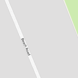

Leaflet © OpenStreetMap contributors
The heatmap indicates the level of crime in the area. The color of the heatmap indicates the crime severity and recency.
Metrics Year-on-Year
- Average area value
- 217,546.00 £Increased by 5.10 %
- Average area rental value
- 750.00 £/moIncreased by 20.77 %
- Est rental Yield
- 4.14 %Increased by 15.00 %
- Crime Rate
- 16.00 %Unchanged by 0.00 %
from 206,986.00 £
from 621.00 £/mo
from 3.60 %
from 16.00 %
Nearby Schools
| Name | Type | Ofsted | Distance |
|---|---|---|---|
| Carter'S Charity Voluntary Controlled Primary School, Preesall | Voluntary Controlled School | Good | 0.59 KM |
| Preesall Fleetwood'S Charity Church Of England Primary School | Voluntary Aided School | Good | 1.96 KM |
| Saint Aidan'S Church Of England High School | Voluntary Aided School | Good | 2.16 KM |
| Stalmine Primary School | Community School | Good | 4.13 KM |
| Springfield House | Other Independent School | 4.39 KM |
Images
Nearby Streets
| Name | Average Price | Average Sqft | Distance |
|---|---|---|---|
| Pinewood Avenue | £ 0 | 0 | 0.00 KM |
Nearby Listings
| Address | Price | Type | Score | Distance |
|---|---|---|---|---|
| 16 Beach Road, Preesall, Poulton-le-Fylde, FY6 0HQ | £ 215,000 | BUY | 6 / 10 | 0.07 KM |
| Pilling Lane, Preesall, Poulton Le Fylde | £ 450,000 | BUY | 7 / 10 | 0.46 KM |
| No. 123, Pilling Lane, Preesall, Lancs FY6 0HG | £ 165,000 | BUY | 5 / 10 | 0.68 KM |
| 116 Pilling Lane, Preesall, Poulton Le Fylde, FY6 0HG | £ 335,500 | BUY | 6 / 10 | 0.69 KM |
| Sandy Bay Caravan Park, 119 Pilling Lane, Preesall, Lancashire | £ 52,995 | BUY | Unknown | 0.69 KM |
Nearby Properties
| Address | Price | Distance |
|---|---|---|
| 7 Beach Road | £ 183,000 | 0.00 KM |
| 2 Beach Road | £ 420,000 | 0.00 KM |
| 10 Beach Road | £ 356,000 | 0.00 KM |
| 14 Beach Road | £ 295,000 | 0.00 KM |
| 25 Beach Road | £ 320,000 | 0.00 KM |